North Canal Project
Project Overview
Project Number: M-43E101-0001
Estimated Budget: $131,071,815
Start: Summer 2027
Completion: Winter 2030
Project Impact Area

Community Feedback
Have questions or feedback about this project? Email us at engage@houstontx.gov or call 311.
Project Overview
Project Number: M-43E101-0001
Estimated Budget: $131,071,815
Start: Summer 2027
Completion: Winter 2030
Project Impact Area
Community Feedback
Have questions or feedback about this project? Email us at engage@houstontx.gov or call 311.
-
Share With the variability of the North Canal channel depth, will water quality be negatively impacted? This is an EA natural environment question. Zooming out some, how will the North Canal impact the natural environment of the confluence of the White Oak and Buffalo Bayous? on Facebook Share With the variability of the North Canal channel depth, will water quality be negatively impacted? This is an EA natural environment question. Zooming out some, how will the North Canal impact the natural environment of the confluence of the White Oak and Buffalo Bayous? on X (formerly Twitter) Share With the variability of the North Canal channel depth, will water quality be negatively impacted? This is an EA natural environment question. Zooming out some, how will the North Canal impact the natural environment of the confluence of the White Oak and Buffalo Bayous? on Linkedin Email With the variability of the North Canal channel depth, will water quality be negatively impacted? This is an EA natural environment question. Zooming out some, how will the North Canal impact the natural environment of the confluence of the White Oak and Buffalo Bayous? link
With the variability of the North Canal channel depth, will water quality be negatively impacted? This is an EA natural environment question. Zooming out some, how will the North Canal impact the natural environment of the confluence of the White Oak and Buffalo Bayous?
almost 2 years agoReady...Set...ENGAGE!
Thank you for engaging with us. Impacts to the natural environment from the proposed North Canal channel will be studied in the design phase in progress and will be mitigated for as determined.
-
Share I’m glad to learn the old ugly and flow restricting railroad trestle just west of Yale will be removed. I wonder if it would be possible to save the outer metal trestle posts for future use as the base of a large gateway public art sculpture? Leaving these two smaller of the four posts in place would save some money and hardly impact flow when compared to the large central trestle supports. on Facebook Share I’m glad to learn the old ugly and flow restricting railroad trestle just west of Yale will be removed. I wonder if it would be possible to save the outer metal trestle posts for future use as the base of a large gateway public art sculpture? Leaving these two smaller of the four posts in place would save some money and hardly impact flow when compared to the large central trestle supports. on X (formerly Twitter) Share I’m glad to learn the old ugly and flow restricting railroad trestle just west of Yale will be removed. I wonder if it would be possible to save the outer metal trestle posts for future use as the base of a large gateway public art sculpture? Leaving these two smaller of the four posts in place would save some money and hardly impact flow when compared to the large central trestle supports. on Linkedin Email I’m glad to learn the old ugly and flow restricting railroad trestle just west of Yale will be removed. I wonder if it would be possible to save the outer metal trestle posts for future use as the base of a large gateway public art sculpture? Leaving these two smaller of the four posts in place would save some money and hardly impact flow when compared to the large central trestle supports. link
I’m glad to learn the old ugly and flow restricting railroad trestle just west of Yale will be removed. I wonder if it would be possible to save the outer metal trestle posts for future use as the base of a large gateway public art sculpture? Leaving these two smaller of the four posts in place would save some money and hardly impact flow when compared to the large central trestle supports.
almost 2 years agoReady...Set...ENGAGE!
Thank you for engaging with us! The project does not have the scope to retain and repurpose portions of the abandoned railroad structure. Suggest you reach out to the Council Member’s office for possibilities on coordinating salvaging and repurposing.
-
Share Bank erosion and sediment deposits on the Share Use Path under I10 and just to the south need to be addressed. With this project and/or TxDOT’s and METRO’s projects at this location there is the opportunity to rectify this problem. on Facebook Share Bank erosion and sediment deposits on the Share Use Path under I10 and just to the south need to be addressed. With this project and/or TxDOT’s and METRO’s projects at this location there is the opportunity to rectify this problem. on X (formerly Twitter) Share Bank erosion and sediment deposits on the Share Use Path under I10 and just to the south need to be addressed. With this project and/or TxDOT’s and METRO’s projects at this location there is the opportunity to rectify this problem. on Linkedin Email Bank erosion and sediment deposits on the Share Use Path under I10 and just to the south need to be addressed. With this project and/or TxDOT’s and METRO’s projects at this location there is the opportunity to rectify this problem. link
Bank erosion and sediment deposits on the Share Use Path under I10 and just to the south need to be addressed. With this project and/or TxDOT’s and METRO’s projects at this location there is the opportunity to rectify this problem.
almost 2 years agoReady...Set...ENGAGE!
Thank you for engaging with us! Your feedback will be shared with the design team for consideration, however comments which would increase project scope will likely not be able to be accommodated in this project.
-
Share In the Studement/I10 area, it appears the Shared Use Path is going to be rerouted which will likely require a closure of the facility. What measures are being proposed to maintain the usability of this key recreational and transportation facility during the construction phase of the project? on Facebook Share In the Studement/I10 area, it appears the Shared Use Path is going to be rerouted which will likely require a closure of the facility. What measures are being proposed to maintain the usability of this key recreational and transportation facility during the construction phase of the project? on X (formerly Twitter) Share In the Studement/I10 area, it appears the Shared Use Path is going to be rerouted which will likely require a closure of the facility. What measures are being proposed to maintain the usability of this key recreational and transportation facility during the construction phase of the project? on Linkedin Email In the Studement/I10 area, it appears the Shared Use Path is going to be rerouted which will likely require a closure of the facility. What measures are being proposed to maintain the usability of this key recreational and transportation facility during the construction phase of the project? link
In the Studement/I10 area, it appears the Shared Use Path is going to be rerouted which will likely require a closure of the facility. What measures are being proposed to maintain the usability of this key recreational and transportation facility during the construction phase of the project?
almost 2 years agoReady...Set...ENGAGE!
Thank you for engaging with us. Correct, portions of the existing trail are expected to be impacted by project construction. Connectivity of the path will be maintained during construction with temporary routes. TxDOT’s IH-10 White Oak Bayou project is anticipated to begin construction and have some similar trail impacts, the North Canal High Flow Diversion Channel project’s designer has those plans for review and temporary rerouting considerations include the possibility of a similar path as TxDOT’s project which I understand uses IH-10 eastbound feeder road sidewalk.
-
Share Will the shared use path be impacted in the Heights/Yale area during construction? Again, maintaining the functionality of the path during construction is key. on Facebook Share Will the shared use path be impacted in the Heights/Yale area during construction? Again, maintaining the functionality of the path during construction is key. on X (formerly Twitter) Share Will the shared use path be impacted in the Heights/Yale area during construction? Again, maintaining the functionality of the path during construction is key. on Linkedin Email Will the shared use path be impacted in the Heights/Yale area during construction? Again, maintaining the functionality of the path during construction is key. link
Will the shared use path be impacted in the Heights/Yale area during construction? Again, maintaining the functionality of the path during construction is key.
almost 2 years agoReady...Set...ENGAGE!
Thank you for engaging with us. Construction of the retaining walls along the shared use path and installation of a proposed railing may require temporary closures of the shared use path. Connectivity of the path will be maintained during construction with temporary routes.
-
Share How will the vertical retaining walls impact bayou wildlife at both Heights/Yale and near Studemont? In EA terms, what are the impacts of these walls on the natural environment? I support this project because I believe it will reduce flood risks along segments of both White Oak and Buffalo Bayous, but without H&H models it is hard to weigh the benefits against possible negative impacts and the high cost of the project. Thank you for this opportunity to comment and ask questions. on Facebook Share How will the vertical retaining walls impact bayou wildlife at both Heights/Yale and near Studemont? In EA terms, what are the impacts of these walls on the natural environment? I support this project because I believe it will reduce flood risks along segments of both White Oak and Buffalo Bayous, but without H&H models it is hard to weigh the benefits against possible negative impacts and the high cost of the project. Thank you for this opportunity to comment and ask questions. on X (formerly Twitter) Share How will the vertical retaining walls impact bayou wildlife at both Heights/Yale and near Studemont? In EA terms, what are the impacts of these walls on the natural environment? I support this project because I believe it will reduce flood risks along segments of both White Oak and Buffalo Bayous, but without H&H models it is hard to weigh the benefits against possible negative impacts and the high cost of the project. Thank you for this opportunity to comment and ask questions. on Linkedin Email How will the vertical retaining walls impact bayou wildlife at both Heights/Yale and near Studemont? In EA terms, what are the impacts of these walls on the natural environment? I support this project because I believe it will reduce flood risks along segments of both White Oak and Buffalo Bayous, but without H&H models it is hard to weigh the benefits against possible negative impacts and the high cost of the project. Thank you for this opportunity to comment and ask questions. link
How will the vertical retaining walls impact bayou wildlife at both Heights/Yale and near Studemont? In EA terms, what are the impacts of these walls on the natural environment? I support this project because I believe it will reduce flood risks along segments of both White Oak and Buffalo Bayous, but without H&H models it is hard to weigh the benefits against possible negative impacts and the high cost of the project. Thank you for this opportunity to comment and ask questions.
almost 2 years agoReady...Set...ENGAGE!
Thank you for engaging with us. Impacts to the natural environment from the proposed Yale/Heights area retaining walls will be studied in the design phase in progress and mitigated will be for as determined. Given that this portion of the existing channel is concrete lined, impacts are not anticipated to be as significant as if it were unlined.
-
Share I appreciate this opportunity to comment and ask questions on the North Canal High Flow Diversion Channel Project. I attended the 8/6/24 public meeting on this project and found the presentation and story boards quite helpful in getting caught up on the most current proposal. When it came to the flood reduction benefits, the public was told the Hydrology and Hydraulic (H&H) studies weren’t complete at the time of the meeting. How is the public supposed to make informed comments on the Project Purpose without this key information? Further, one can’t make informed comment on the Purpose and Need section of an Environmental Assessment (EA) without the H&H information. on Facebook Share I appreciate this opportunity to comment and ask questions on the North Canal High Flow Diversion Channel Project. I attended the 8/6/24 public meeting on this project and found the presentation and story boards quite helpful in getting caught up on the most current proposal. When it came to the flood reduction benefits, the public was told the Hydrology and Hydraulic (H&H) studies weren’t complete at the time of the meeting. How is the public supposed to make informed comments on the Project Purpose without this key information? Further, one can’t make informed comment on the Purpose and Need section of an Environmental Assessment (EA) without the H&H information. on X (formerly Twitter) Share I appreciate this opportunity to comment and ask questions on the North Canal High Flow Diversion Channel Project. I attended the 8/6/24 public meeting on this project and found the presentation and story boards quite helpful in getting caught up on the most current proposal. When it came to the flood reduction benefits, the public was told the Hydrology and Hydraulic (H&H) studies weren’t complete at the time of the meeting. How is the public supposed to make informed comments on the Project Purpose without this key information? Further, one can’t make informed comment on the Purpose and Need section of an Environmental Assessment (EA) without the H&H information. on Linkedin Email I appreciate this opportunity to comment and ask questions on the North Canal High Flow Diversion Channel Project. I attended the 8/6/24 public meeting on this project and found the presentation and story boards quite helpful in getting caught up on the most current proposal. When it came to the flood reduction benefits, the public was told the Hydrology and Hydraulic (H&H) studies weren’t complete at the time of the meeting. How is the public supposed to make informed comments on the Project Purpose without this key information? Further, one can’t make informed comment on the Purpose and Need section of an Environmental Assessment (EA) without the H&H information. link
I appreciate this opportunity to comment and ask questions on the North Canal High Flow Diversion Channel Project. I attended the 8/6/24 public meeting on this project and found the presentation and story boards quite helpful in getting caught up on the most current proposal. When it came to the flood reduction benefits, the public was told the Hydrology and Hydraulic (H&H) studies weren’t complete at the time of the meeting. How is the public supposed to make informed comments on the Project Purpose without this key information? Further, one can’t make informed comment on the Purpose and Need section of an Environmental Assessment (EA) without the H&H information.
almost 2 years agoReady...Set...ENGAGE!
Thank you for engaging with us. The project is currently in the City of Houston Phase 2 Final Design, refinement of the design features need to occur then H&H modeling will be performed incorporating it. Updated modeling results are anticipated to be done by the time of the next Public Meeting which is anticipated first quarter of next year. Then note the design effort began with City of Houston Phase 1 Preliminary Design, Alternative 2 most closely resembles the current design scheme (North Canal with Yale Heights). H&H results for Alternative 2 from COH Phase 1 can be found at:https://www.engagehouston.org/northcanal webpage in the far right side ‘Documents’ link to the Technical Review Committee with Record of Decisions and Action Items Aug. 3, 2022.pdf’
-
Share • It appears only a bare minimum of the METRO property is being acquired. My concern is erosion of the north Bank of Buffalo Bayou just downstream of the North Canal and adjacent to the railroad tracks. How will the North Canal impact erosion in this area? If more of the METRO property were to be acquired, the possibility would exist to relocate the railroad tracks slightly to the north and engineer a solution to the erosion of the bank in this area. In the context of the EA, this area appears to be part of the Affected Environment that may require Mitigation Measures. on Facebook Share • It appears only a bare minimum of the METRO property is being acquired. My concern is erosion of the north Bank of Buffalo Bayou just downstream of the North Canal and adjacent to the railroad tracks. How will the North Canal impact erosion in this area? If more of the METRO property were to be acquired, the possibility would exist to relocate the railroad tracks slightly to the north and engineer a solution to the erosion of the bank in this area. In the context of the EA, this area appears to be part of the Affected Environment that may require Mitigation Measures. on X (formerly Twitter) Share • It appears only a bare minimum of the METRO property is being acquired. My concern is erosion of the north Bank of Buffalo Bayou just downstream of the North Canal and adjacent to the railroad tracks. How will the North Canal impact erosion in this area? If more of the METRO property were to be acquired, the possibility would exist to relocate the railroad tracks slightly to the north and engineer a solution to the erosion of the bank in this area. In the context of the EA, this area appears to be part of the Affected Environment that may require Mitigation Measures. on Linkedin Email • It appears only a bare minimum of the METRO property is being acquired. My concern is erosion of the north Bank of Buffalo Bayou just downstream of the North Canal and adjacent to the railroad tracks. How will the North Canal impact erosion in this area? If more of the METRO property were to be acquired, the possibility would exist to relocate the railroad tracks slightly to the north and engineer a solution to the erosion of the bank in this area. In the context of the EA, this area appears to be part of the Affected Environment that may require Mitigation Measures. link
• It appears only a bare minimum of the METRO property is being acquired. My concern is erosion of the north Bank of Buffalo Bayou just downstream of the North Canal and adjacent to the railroad tracks. How will the North Canal impact erosion in this area? If more of the METRO property were to be acquired, the possibility would exist to relocate the railroad tracks slightly to the north and engineer a solution to the erosion of the bank in this area. In the context of the EA, this area appears to be part of the Affected Environment that may require Mitigation Measures.
almost 2 years agoReady...Set...ENGAGE!
Thank you for engaging with us. Yes, the north bank of Buffalo Bayou downstream of the proposed North Canal channel to approximately McKee Street is within the current project’s scope to provide mitigation of erosion due to the added North Canal channel connection at Buffalo Bayou.
-
Share In my previous question about the 3 foot depth at the waste water structure vs an 8 foot depth elsewhere how can a five foot speed bump not impede water flow? on Facebook Share In my previous question about the 3 foot depth at the waste water structure vs an 8 foot depth elsewhere how can a five foot speed bump not impede water flow? on X (formerly Twitter) Share In my previous question about the 3 foot depth at the waste water structure vs an 8 foot depth elsewhere how can a five foot speed bump not impede water flow? on Linkedin Email In my previous question about the 3 foot depth at the waste water structure vs an 8 foot depth elsewhere how can a five foot speed bump not impede water flow? link
In my previous question about the 3 foot depth at the waste water structure vs an 8 foot depth elsewhere how can a five foot speed bump not impede water flow?
Randy asked almost 2 years agoReady...Set...ENGAGE!
Thank you for engaging with us! The North Canal channel will have an approximate overall 35-foot average depth from the top of the bank at street-grade level to the bottom of the channel. The bottom of the channel will rise with a gentle slope from the upstream end to provide adequate clearance over the existing large-diameter wastewater pipe, then have a gentle slope downward to the downstream end of the channel at Buffalo Bayou. Water flow in the channel will have a constant average water depth of 3 feet to 8 feet, depending upon the location along the length of the channel, with the utilization of the overall channel depth depending upon the flow from storm events. Thank you for your time and patience!
-
Share Question 1 for me is that on page 21 of last nights presentation there is a note of a 3-8 foot depth and it was mentioned that was because of the sewer stuff there which I guess is where every time we get a heavy rainfall there is a sewage spill but also will that be a blockage of water flow that means continued flooding at that point? Might it be a good idea to make the water flow at this point without flooding or sewage leaks part of the design of this project? on Facebook Share Question 1 for me is that on page 21 of last nights presentation there is a note of a 3-8 foot depth and it was mentioned that was because of the sewer stuff there which I guess is where every time we get a heavy rainfall there is a sewage spill but also will that be a blockage of water flow that means continued flooding at that point? Might it be a good idea to make the water flow at this point without flooding or sewage leaks part of the design of this project? on X (formerly Twitter) Share Question 1 for me is that on page 21 of last nights presentation there is a note of a 3-8 foot depth and it was mentioned that was because of the sewer stuff there which I guess is where every time we get a heavy rainfall there is a sewage spill but also will that be a blockage of water flow that means continued flooding at that point? Might it be a good idea to make the water flow at this point without flooding or sewage leaks part of the design of this project? on Linkedin Email Question 1 for me is that on page 21 of last nights presentation there is a note of a 3-8 foot depth and it was mentioned that was because of the sewer stuff there which I guess is where every time we get a heavy rainfall there is a sewage spill but also will that be a blockage of water flow that means continued flooding at that point? Might it be a good idea to make the water flow at this point without flooding or sewage leaks part of the design of this project? link
Question 1 for me is that on page 21 of last nights presentation there is a note of a 3-8 foot depth and it was mentioned that was because of the sewer stuff there which I guess is where every time we get a heavy rainfall there is a sewage spill but also will that be a blockage of water flow that means continued flooding at that point? Might it be a good idea to make the water flow at this point without flooding or sewage leaks part of the design of this project?
Randy asked almost 2 years agoReady...Set...ENGAGE!
Thank you for your involvement in the North Canal Project. The design of the project will involve addressing the existing large-diameter wastewater crossing under the proposed North Canal channel. The wastewater will not impede the flow in the channel; it will have sufficient cover beneath the proposed channel bottom.
Follow Project
Project Timeline
-
Design
North Canal Project is currently at this stage -
Construction
this is an upcoming stage for North Canal Project -
Complete
this is an upcoming stage for North Canal Project
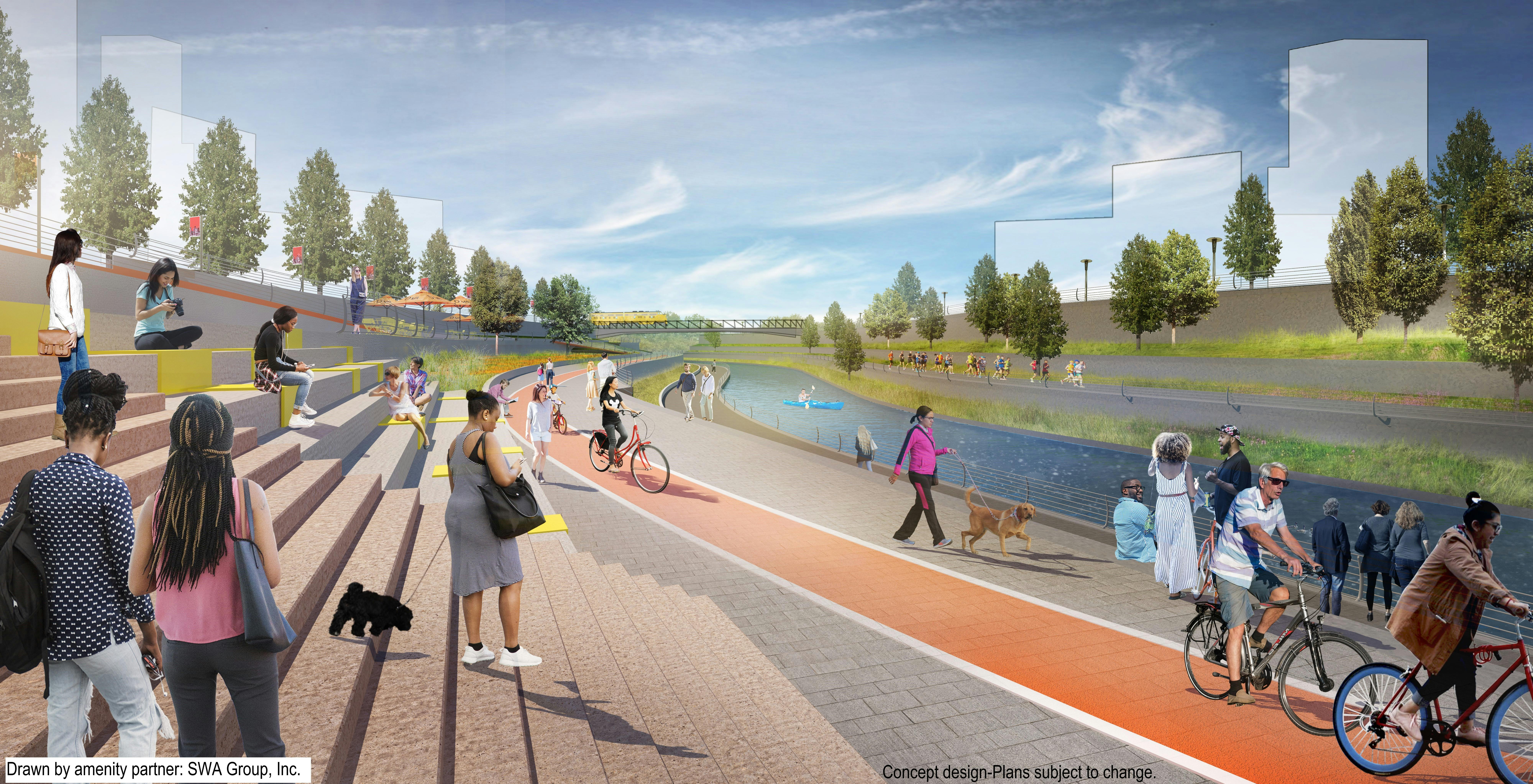
Why This Project Matters
The North Canal Project is a major flood mitigation effort focused on protecting downtown Houston and nearby neighborhoods from serious flood damage. Here’s why it’s important:
1. Reduces Flooding in Key Areas
By creating a high-flow diversion channel and making improvements at the confluence of White Oak and Buffalo Bayous, this project helps manage large volumes of stormwater—reducing the risk of flooding in downtown and upstream communities.
2. Protects Homes and Businesses
Improved channel capacity means water moves more efficiently, lowering the chances of flood damage to properties along White Oak and Buffalo Bayous during major rain events.
3. Leverages Federal and Local Support
This project is part of FEMA’s Hazard Mitigation Grant Program. With funding support from the federal government, the City of Houston, and several local partners, the project represents a strong investment in long-term flood protection.
4. Strengthens Infrastructure Through Partnerships
The City is working with the Harris County Flood Control District, TxDOT, and Memorial Heights Redevelopment Authority (on behalf of TIRZ No. 5), combining resources and expertise to deliver this critical infrastructure.
5. Builds a More Resilient Houston
By addressing a major flood risk area with large-scale improvements, the North Canal Project helps Houston prepare for future storms and supports a safer, more sustainable future for residents and businesses alike.
Documents & Downloads
-
 North Canal Project Factsheet August 2024.pdf (3.14 MB) (pdf)
-
North Canal Factsheets English (5.26 MB) (pdf)
-
North Canal Factsheet Spanish (1.41 MB) (pdf)
-
North Canal Meeting English Presentation 8-6-2024 (7.29 MB) (pdf)
-
North Canal Meeting Spanish Presentation 8-6-2024 (7.12 MB) (pdf)
-
Frequently Asked Questions (42.9 KB) (pdf)
-
Project Timeline (805 KB) (pdf)
-
Technical Review Committee Presentation Mar. 17, 2022 (18 MB) (pdf)
-
Technical Review Committee with Record of Decisions and Action Items Aug. 3, 2022 (26 MB) (pdf)
-
North Canal Presentation 05-24-2023.pdf (3.37 MB) (pdf)